Very useful all-around maps of the Dularge area can be obtained from
Standard Map Service.
These are detailed enough to assist in getting around, but they are
small enought to roll up and put in your center console. The maps
you will want for the Dularge area are
No. 14 (Cocodrie);
No. 21 (Four League Bay); and
No. 19 (Last Island).
A final caveat: The aerial maps are "not for navigation." The
Dularge area is very shallow, and just because there is water in front
of you doesn't necessarily mean you can go there. Try to stay in
the major lakes and bayous - explore the smaller cuts and shallower
areas after you know the area. You are going tot get stuck - it
is a certainty. Be prepared to get yourself out or pack a
lot of vienna sausages to eat while you wait for the tide
to come back up.
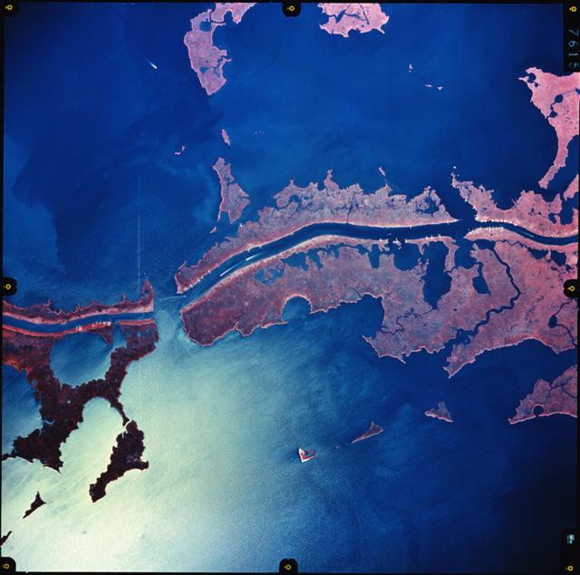 The "gold standard" when it comes to aerial photos of the Dularge area are the Color Infrared Aerials that were taken in 2000
to study the "brown marsh" phenomenon. These aerials are very
high resolution and show a great detail. One can make out individual
potholes, and if you look closely enough, you can even see some barely
submerged shell reefs. The drawback for these areials is that
they are extremely large files. You should have a DSL or Cable
modem to download. At one point, I downloaded many of these
photos and had them printed and laminatied by a buddy of mine. In
the end, they were beautiful, but simply too large and unwieldy for
everyday use. They are very good for duck pond research sessions
back at the house or office, (or back on Brutus or Petronius for that
matter).
The "gold standard" when it comes to aerial photos of the Dularge area are the Color Infrared Aerials that were taken in 2000
to study the "brown marsh" phenomenon. These aerials are very
high resolution and show a great detail. One can make out individual
potholes, and if you look closely enough, you can even see some barely
submerged shell reefs. The drawback for these areials is that
they are extremely large files. You should have a DSL or Cable
modem to download. At one point, I downloaded many of these
photos and had them printed and laminatied by a buddy of mine. In
the end, they were beautiful, but simply too large and unwieldy for
everyday use. They are very good for duck pond research sessions
back at the house or office, (or back on Brutus or Petronius for that
matter).